
[See Disclaimer below, regarding citizen grassroots volunteers and website]
AMERICAN RIVER TREES
MORE ABOUT THE ARMY CORPS (USACE) CONTRACT (PROJECT) "3B"
URGENT!
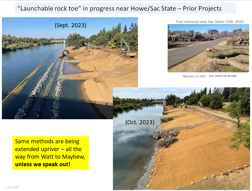
In late 2023, the U.S. Army Corps of Engineers (USACE) officially released its upcoming Project “Contract 3B” environmental analysis for public comment. Project 3B is slated to bulldoze over 600 trees in an especially pristine stretch of the American River Parkway, as this new plan pushes extremely destructive methods (claimed to be needed for “bank erosion potential”) more miles further upstream beyond similar work projects that have already been occurring near Sacramento State University. Those prior projects bulldozed nearly all trees in the work zones, an left barren dirt banks, as seen in the right-hand photo below taken from the Howe Ave bridge where prior contracts were underway.
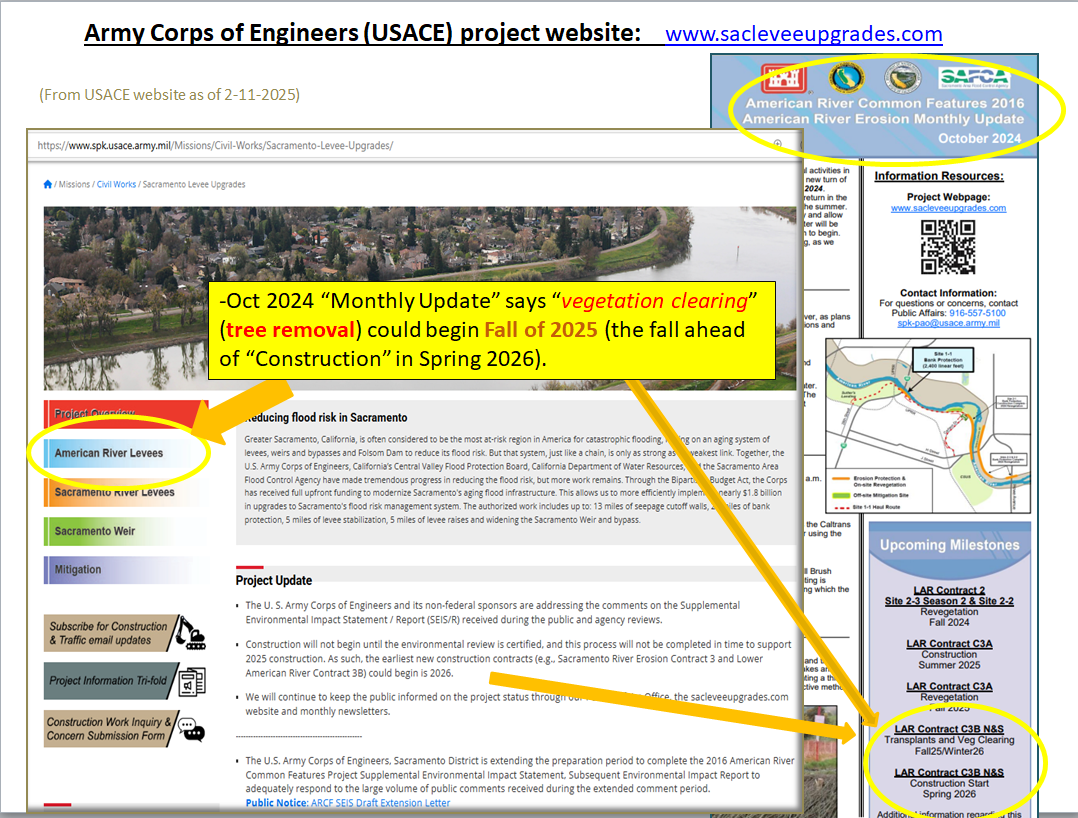
In October 2024, USACE announced they were still responding to about 1,000 complex public comments regarding proposed “3B”, and have delayed the start of “3B” for about a year. (Vegetation removal would begin in the fall of 2025). During this time it is urgent we continue to press the agencies and our elected leaders to insist on ALTERNATIVE DESIGNS that are less destructive.

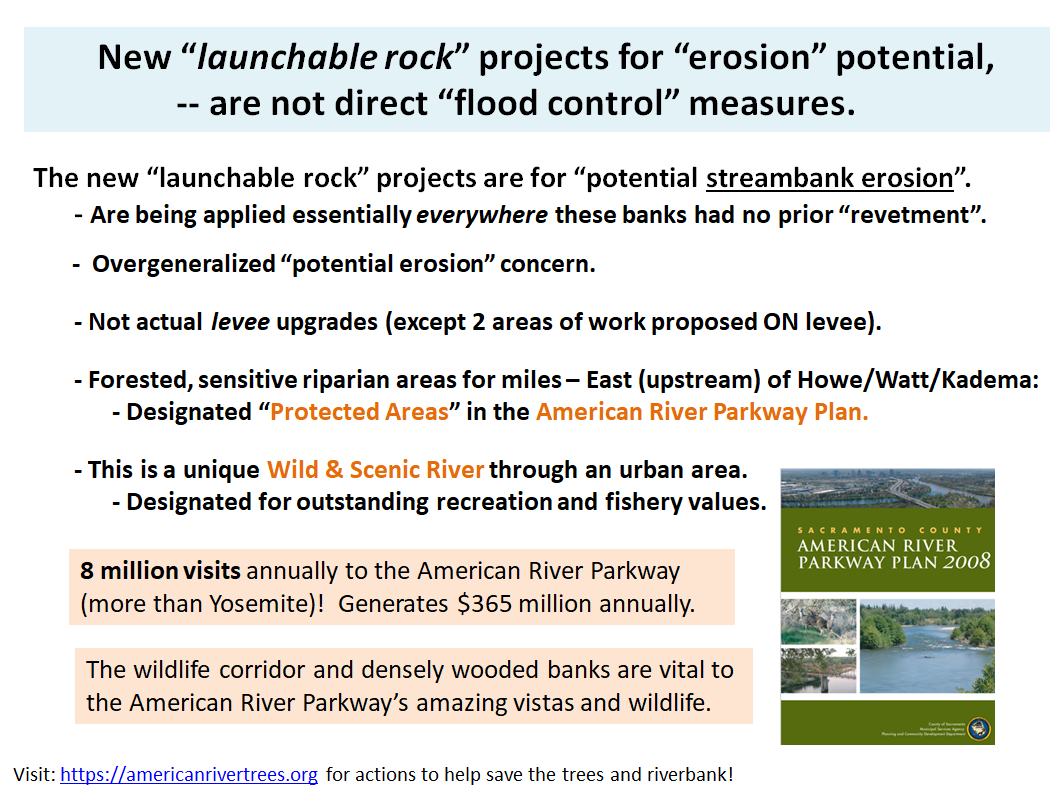
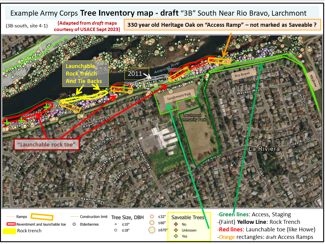
The same methods are planned in Project 3B, which extends from Watt Ave east (upstream) behind Rogue River, Larchmont Park, Rio Bravo/Mayhew on the south bank (site 4-1), and from Howe Ave to the Estates Dr area on the north bank. The Army Corps proposes heavy equipment staging areas (including Larchmont Park), haul roads through neighborhoods, and destructive “access ramps” needed for bulldozers and big trucks, in addition to the actual project work zones, involving bulldozing of most of the trees along river banks in order to install their “launchable rock toes” and “trenches” as “revetments” to supposedly prevent “bank erosion” at the normal water’s edge river banks. This massively destructive approach is not justified in this upstream area, which is relatively straight with low modeled velocities at the banks. This upcoming 3B project would extend the extremely damaging engineering methods into a designated “Protected area” under the American River Parkway Plan, and the American River is also a federal and state Wild and Scenic River.


**
Tips on using the USACE website:
FAQs
-
DOWNLOAD THIS INFO AS A PDF WITH PHOTOS
What’s happening?
The Army Corps of Engineers is slated to continue their next phase of large-scale river surgery upstream into the American River Parkway, from Howe Bridge to the Mayhew Drain, over about three river miles. This is part of a larger effort to ensure Greater Sacramento can accommodate more floodwater volume during wet periods, due in part to climate change. The sole focus for the American River is erosion control for the river banks and levees. Overtopping or seepage issues were not identified in need of correction.
The proposed solution is to remove the large majority of trees and virtually all of the ground cover that lines the river bank, to add rocks and soil to the cleared stretches, and to attempt to plant trees again, all over a short period of time. This approach has drawn a considerable amount of public concern.
Why are we alarmed?
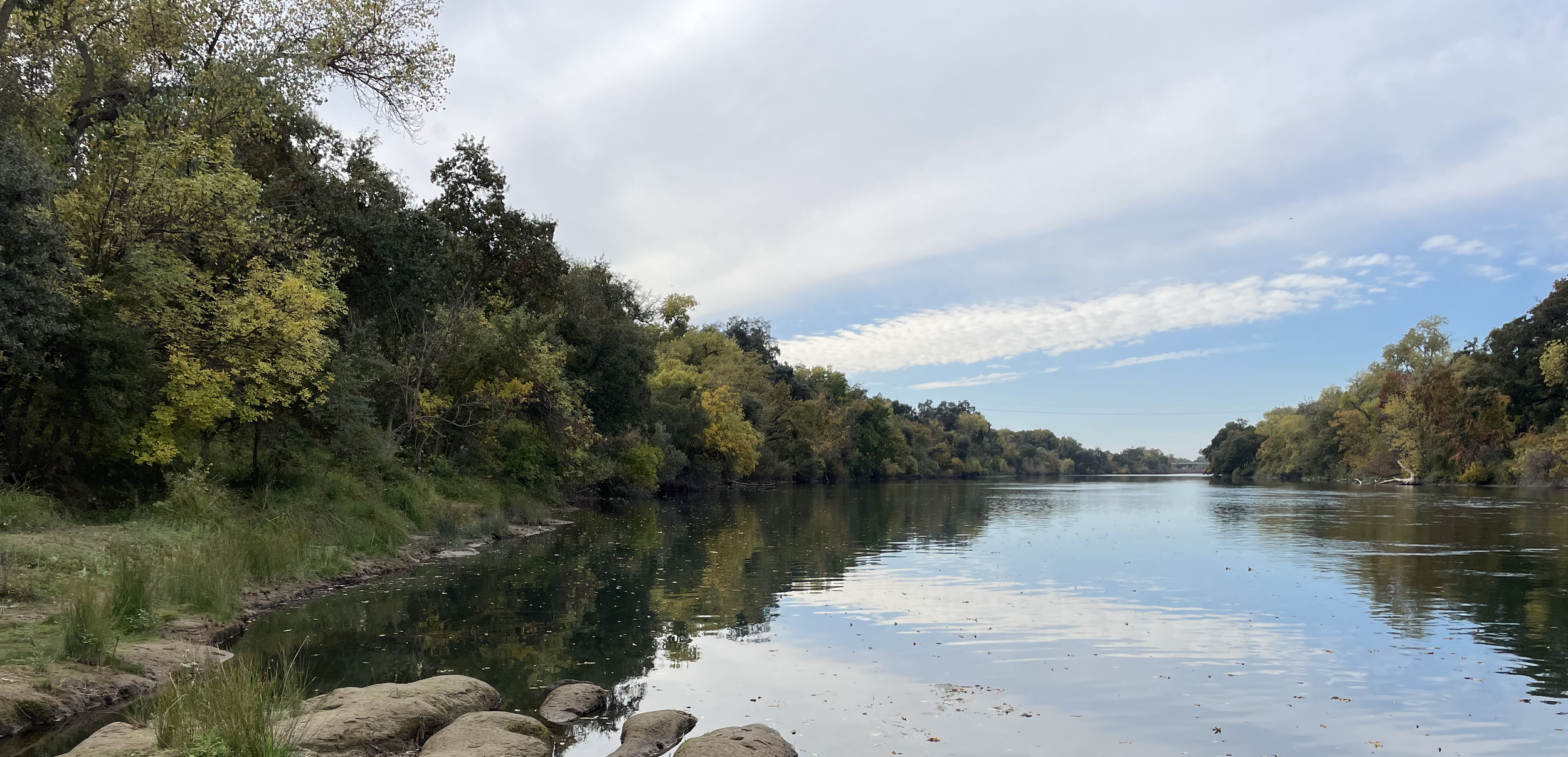
Overall, eleven of the Lower American River Parkway’s twenty six miles are at risk for forest removal, and so far revegetation of bulldozed sections downstream has not gone as planned. The next targeted stretch of channel work contains mature riparian forest with thousands of trees providing square miles of critical habitat and temperature refuge for aquatic and terrestrial species. These ecosystems provide many important services for society, such as maintaining water quality, naturally armoring river banks and increasing resistance to erosive shear stress, and providing recreation and nature space. The area, a lush riparian corridor, is a coveted green space full of trails, beaches, picnic and fishing areas, and river accessways for swimming or small watercraft. The riverbank is critical habitat for endangered Salmonids and other threatened or endangered species. If the project goes forward, most of these resources and activities from multi-mile stretches of river will likely vanish. The Lower American Parkway is one of the few major green spaces in Sacramento and sees more than five million visits a year. Losing major portions of this resource may also cause economic harm. There’s considerable uncertainty whether fundamental components of the construction work are allowable in a Wild and Scenic river, and there are rumors the project’s aggressive schedule is due to impending funding loss deadlines..
Why do we question the proposed solution?
We are skeptical of the evidence provided to justify the need for such a massive intervention. We believe a project of this consequence deserves more investigation, into both diagnosis methods and treatment options. We advocate for using modern analysis methods, maximizing the use of innovative nature-based solutions1 (NbS), and letting the public participate in the project’s strategy and approach.
What causes river bank erosion?
Major factors include how fast the water flows close to the river banks during various ranges of high flows and how susceptible the material near the river bank is to erosion. It is well known that vegetation and trees along river banks - roughness - cause slower water near the river banks. If revegetation does not go as planned, the with-project condition to address erosion will cause faster, more erosive water at the river banks..
How do we predict what might happen?
We have some evidence of the river’s behavior under various flood conditions but the major predictive tool is computer modeling of water flow at levels that haven’t been seen recently. In the last decade this kind of modeling has seen particular growth in applied sciences and engineering. However, the modeling conducted for the construction project dates back to 2004, and is potentially dangerously oversimplified. More modern but still very affordable computational fluid dynamics modelling, and more accurate geologic models, would yield a fresh look at predictions of erosion risk.
Roots vs Rocks?
Many of the oaks along this stretch of the river are older than the US, and have held steady to the bank during flood flows before and after Folsom Dam was constructed. Is it really the best solution to remove nearly all the trees to replace them with riprap? How successful will it be to replant trees in an area where large rocks impede root growth and lack of shade might stunt new saplings? Is the construction style planned generally using modern concepts of river engineering and nature-based strategies, or is it more of an outdated, heavy-handed, one-size-fits-all approach applied to a complex riverine environment? The American River Common Features project dates back to the 1990s.
What’s next?
With State-of-California and federal designation as a Wild and Scenic River, and the only Wild & Scenic river in the United States to pass through a major metropolitan area, the Lower American River truly is the crown jewel of Sacramento, and it’s in need of special attention and a second opinion before undergoing more surgery. We believe the project should be paused and alternative solutions investigated through further study with extensive peer review.
The public comment period for the project closed February 23, 2024.
For latest actions you can take, go here.
______________________________
1 Solutions that are inspired and supported by nature, which are cost-effective, simultaneously provide environmental, social and economic benefits and help build resilience. Such solutions bring more nature and natural features and processes into cities, landscapes and seascapes, through locally adapted, resource-efficient and systemic interventions. European Commission 2020.
-
The sooner the better, and to all that are relevant and that you would like. Your timely emails help raise awareness among our public leaders to the concerns, and we hope to influence some imminent decisions. For example, the USACE proposal will be seeking Sacramento Regional Parks and the National Park Service to make findings regarding whether or not there is “consistency” with the Wild and Scenic Rivers Act. “Conditions” could be required by Sac Regional Parks before finding “consistency”. Hearing from many people that raise concerns is valuable, and hearing they want to see alternatives – particularly because this stretch of river is not only a “Protected area” of the Parkway and Wild and Scenic River, but any need for this type of sweeping and massive bank erosion work is much less compelling here, compared to other regions around the Sacramento area that still needed actual levee upgrades (e.g., slurry cutoff walls), to be covered in those other regions under the 2016 “umbrella” analysis. By contrast, the upper reaches of 3B-south already had all those flood control measures fully completed. Minor spots of erosion should be evaluated for much more targeted and less destructive methods in this zone, if needed at all.